 Talking Science Podcast
Cyclones, Hurricanes and Typhoons – Engines of the Warm Ocean
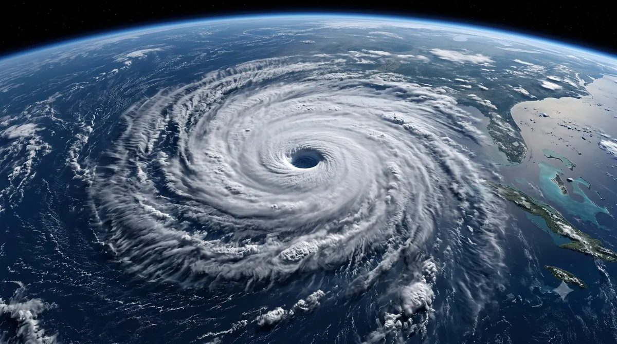
From above, it looks almost peaceful: a great white spiral of cloud, hundreds of kilometres across, turning slowly over the sea with a calm dark eye at its centre. On the ground, it is anything but peaceful. It is one of the most powerful events in nature, a storm capable of flattening coastlines and reshaping lives in a single day. We call it a hurricane, a typhoon, or a cyclone depending on where it forms, but it is the same beast: a giant engine that runs on the warmth of the ocean.
One storm, three names
Let us clear up the names first, because they cause endless confusion. Hurricanes, typhoons, and tropical cyclones are all the same kind of storm. The only difference is geography. In the Atlantic and the eastern Pacific, near the Americas, we call them hurricanes. In the western Pacific, near Asia, they are typhoons. In the Indian Ocean and around Australia, they are simply called cyclones. Scientists use the umbrella term “tropical cyclone” for all of them.
Whatever the label, the recipe is the same. These storms are born over warm tropical seas, they spin because of the rotation of the Earth, and they draw their ferocious energy from one source above all: heat stored in the surface waters of the ocean.
The warm ocean as fuel
To understand these storms, think of the ocean as a giant battery charged by the Sun. Through spring and summer, sunlight warms the top layer of tropical seas until the water is bathwater-warm, typically above about 26 degrees Celsius. That warm water is the fuel.
Here is the crucial trick. When water evaporates from the warm sea, it carries energy with it in the form of invisible water vapour. As that moist air rises and the vapour condenses back into cloud droplets high above, it releases that stored energy as heat. This released heat warms the surrounding air, making it rise even faster, which pulls in more moist air from the sea below, which releases still more heat. A self-feeding cycle takes hold, and a cluster of thunderstorms can organise into a spinning giant. In effect, the storm is a machine for converting ocean warmth into wind.
Why they spin
A tropical cyclone is defined by its rotation, and that spin comes from the planet itself. As air rushes in toward the low-pressure centre of the storm, the Earth’s rotation deflects it, curving the flow into a great swirl. This deflection is known as the Coriolis effect. Because of the way the Earth turns, storms spin one way in the Northern Hemisphere and the opposite way in the Southern.
This same effect explains why tropical cyclones never form right on the equator. There, the deflecting force is too weak to get the air spinning, so the storms are born a little further north or south, where the planet’s rotation can set the spiral in motion.
At the heart of the mature storm sits the eye, a region of calm, sinking air, often clear enough to see the sky. Ringing it is the eyewall, a towering wall of cloud where the winds are fiercest and the rain heaviest. Outside that, long spiral bands of storm clouds wheel around the centre.
Where the danger lies
When we think of these storms we picture screaming winds, and the wind is certainly destructive. But some of the greatest dangers are quieter. One is the storm surge: as the cyclone’s winds pile ocean water against the coast, the sea can rise far above its normal level and flood low-lying land, drowning whole districts. Storm surge has historically been one of the deadliest features of these storms.
Water is the recurring theme of the danger. Tropical cyclones also carry enormous amounts of rain, and a slow-moving storm can dump it for days, causing rivers to burst and hillsides to slide. Some of the worst disasters have come not from the wind but from flooding far inland, long after the storm crossed the coast. The wind grabs the headlines, but water often does the greatest harm.
A warming world and a warming sea
Because these storms feed on ocean heat, a warming world naturally raises questions about their future. Scientists are careful here, because the picture is nuanced. There is no simple sign that the total number of tropical cyclones each year is climbing. But there is growing evidence that warmer seas make the strongest storms more likely to reach the highest intensities, and a warmer atmosphere holds more moisture, meaning heavier rainfall.
On top of this, rising sea levels give every storm surge a higher starting point, so the same storm can flood further inland than it would have a century ago. In short, the concern is less about more storms and more about worse ones: fiercer winds, heavier rains, and more damaging floods when the big ones strike.
Watching and warning
The good news is that we are far better at seeing these storms coming than we used to be. Satellites keep constant watch over the tropical oceans, spotting the first swirl of organising clouds days before a storm reaches land. Aircraft fly directly into some cyclones to measure their winds and pressure from the inside, and computer models crunch all this information to forecast where a storm will go and how strong it will become.
These warnings save enormous numbers of lives. A generation or two ago, a powerful cyclone could strike a coast with little notice, and the human toll was often catastrophic. Today, forecasts give communities time to evacuate low-lying areas, secure boats, and move to safer ground. The storms themselves are no weaker, but our ability to prepare for them has transformed. It is one of the clearest examples of scientific understanding turned directly into lives protected.
A tropical cyclone is a humbling reminder of how much energy the ocean quietly stores, and how dramatically that energy can be unleashed. It is a natural engine of astonishing scale, converting the gentle warmth of a summer sea into winds that can bend the world. Understanding how these storms are built, and what feeds them, is not just fascinating science. It is knowledge that helps millions of people prepare for the day the spiral turns toward their shore.