 Talking Science Podcast
Sea Level Rise – Why It Isn't the Same Everywhere
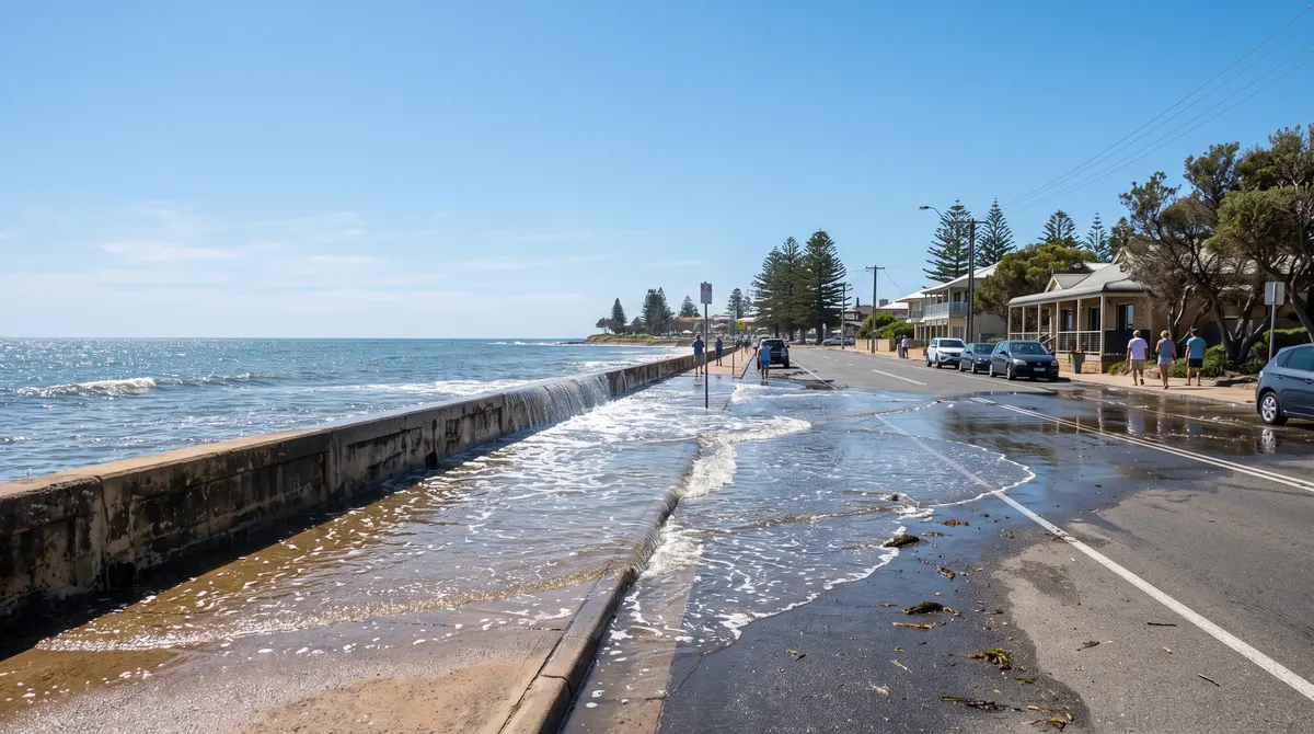
Picture a coastal street on a perfectly clear afternoon. No clouds, no rain, no wind to speak of. Yet seawater is quietly bubbling up out of the stormwater drains and spreading across the road. In a number of low-lying cities around the world, this kind of "sunny day flooding" during unusually high tides, the ones Australians call king tides, has become a recurring nuisance rather than a freak event.
It is one of the most visible everyday signs of sea level rise. But the ocean is not filling up like a bathtub. Why it rises, and why it rises differently from coast to coast, involves expanding water, melting ice, shifting gravity and moving land.
What Sea Level Rise Actually Means
Global mean sea level is the average height of the ocean surface across the planet, smoothed over tides, waves and weather. It has been rising for well over a century, in recent decades by a few millimetres a year, and the rate has been speeding up compared with the twentieth-century average. Two main processes do most of the work.
Warm Water Takes Up More Room
The first is thermal expansion. As seawater absorbs heat, its molecules jostle more vigorously and, on average, spread slightly further apart. Most substances do this when they warm. In a single glass of water the effect is far too small to notice. Across an ocean that covers most of the planet and runs kilometres deep, it adds up to a real increase in volume, and therefore in sea level, without a single extra drop being added.
The ocean has soaked up an enormous share of the extra heat trapped by the warming climate, as explained in Climate Change – The Physics Behind It, and the resulting expansion has been a major contributor to the rise.
Which Ice Matters, and Which Doesn't
The second cause is new water, mostly from melting land ice. Here a common misunderstanding is worth clearing up: not all melting ice raises sea level.
Sea ice, frozen seawater floating around the Arctic and Antarctica, is already displacing its own weight in water, the principle first worked out by Archimedes that explains why a melting ice cube does not overflow a full glass. Shrinking Arctic sea ice is a serious sign of warming, but its melting does not meaningfully lift sea level.
Land ice is different. Mountain glaciers and the vast ice sheets of Greenland and Antarctica, which hold most of the world's fresh water, are not yet part of the ocean. When that ice melts, or breaks off into the sea in a process called calving, it adds new water. Glaciers have been retreating for decades, and both ice sheets have been losing mass overall. Together with thermal expansion, that accounts for most of the rise so far.
The Gravitational Fingerprint
Here is a genuine surprise: melting ice does not raise the sea evenly, and close to a melting ice sheet, sea level can actually fall. A giant ice sheet like Greenland's has so much mass that its gravity pulls nearby seawater towards it. As the ice shrinks, that pull weakens, and the water relaxes outward towards distant oceans. Sea level can drop near the ice while rising by more than the global average far away.
Each ice sheet leaves its own distinctive, calculable pattern across the oceans, called a sea level fingerprint. This is well-established physics, not speculation. One consequence is that ice lost from Greenland tends to raise sea level more in distant parts of the Southern Hemisphere, including around Australia, than close to Greenland itself.
When the Land Moves Too
The ground under a coastline is often moving independently of the ocean, and that can matter just as much. Many low-lying cities are slowly sinking, a process called subsidence. It is often driven or worsened by pumping groundwater, oil or gas from underground, which lets the layers above compact, as well as by the natural settling of soft river-delta sediment. Where land sinks while the sea rises, the water appears to climb much faster than the global average.
Elsewhere the opposite happens. During the last ice age, huge ice sheets squashed the crust under parts of Scandinavia and Canada. That ice vanished thousands of years ago, but the crust is still slowly springing back, like a mattress after a weight is lifted, and in some places local sea level is falling slightly even as the global average rises. For more on that frozen past, see The Ice Ages – When the World Froze Over.
Ocean currents add another layer, piling up warm, expanded water in some regions, and shifting circulation has been linked to faster rise along parts of the United States east coast. So any coastline is shaped by several stacked effects:
- How much its nearby ocean has warmed and expanded.
- Where it sits relative to each melting ice sheet's fingerprint.
- Whether the land itself is sinking or rebounding.
- How regional currents are behaving.
Measuring the Sea, and Why Millimetres Matter
Untangling all this takes two methods. The tide gauge is fixed to the coast and records water height against a point on land; Sydney's Fort Denison gauge has records stretching back to the late nineteenth century. Because it is anchored to land, a gauge captures rising sea and land movement together, which is exactly what a local community experiences.
Satellite altimetry, in continuous use since the early 1990s, bounces precisely timed radar pulses off the sea to measure its height across almost the entire globe. Measured against the centre of the Earth rather than shifting coastline, it gives a cleaner global average. Cross-checking the two has given scientists strong confidence in the trend.
Why do a few millimetres matter? Because sea level is the baseline on which every high tide, storm surge and onshore gale sits. Lift it a little and water that once stayed below a seawall or drain spills over, which is why sunny day flooding is now far more frequent in some cities.
Low-lying island nations, some only a metre or two above the sea, and crowded river deltas face the sharpest version of this, which is why planners increasingly rely on detailed local projections.
Honest Ranges, Not False Precision
The broad picture is not in serious scientific doubt: the ocean is warming and expanding, land ice is melting, and the rise measured so far is well documented. What is less certain is how fast it will continue. Parts of the Antarctic ice sheet rest on ground below sea level, an arrangement some glaciologists consider vulnerable to self-reinforcing retreat if warm ocean water melts the ice from below. That process is hard to model with full confidence.
So credible projections are given as ranges tied to different future emissions. That is not a weakness in the science. The future rate depends partly on choices about emissions not yet made, and partly on ice physics still being pinned down. Uncertainty about speed is a very different thing from doubt about direction.
Where the Physics Becomes Visible
The sea is not simply rising. It is being warmed, pushed, pulled and redistributed by forces across the whole planet, while the land beneath some coasts sinks and beneath others rises. A street filling with seawater on a cloudless day is where that complexity becomes something you can see.